Monday, November 30, 2015

Slowing Down in the Southwest

Post by Henry

We've arrived in the last state of our 2015 journey.....Arizona!

We're staying at the Escapees North Ranch RV Park in Congress, Arizona which is about fifty (50) miles northwest of Phoenix.  The park is set in the middle of BLM (Bureau of Land Management) land with a view of the Weaver Mountains out our window.

Mountains (in background)
Seen From our Window

The front section of the park contains roughly one hundred (100) RV sites with full hookups.  The back of the park are permanent residents with quite an eclectic mix of housing.

In one corner of the park, there's a cactus garden called Saguaro Park.  Here is an assortment of cacti, including one Saguaro estimated to date back to the 1600's, appropriately named Methuselah.

Methuselah, the Saguaro

Argentina Maxima


Joshua Trees and a Saguaro

Yellow Barrel Cactus

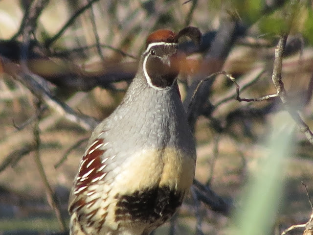
Rabbits and Gamble Quail can be seen scurrying about most everywhere in the park.

Gamble Quail

Since we arrived here a few weeks ago, we've just kind of chilled out.  We've been on a few short trips exploring the area - Prescott, Phoenix, Wickenburg, and Yarnell - but mostly we've been hanging out here at the park. Loretta's been working on sewing projects and attending 'stitch and chat' meetings at the clubhouse.  I've been doing some hiking in the BLM area behind the park and even played golf for the first time in over ten (10) years. (I still suck!)

We've reconnected here at the park with a couple we met at the beginning of the year at the Sumter Oaks Escapees Park in Florida.  Stuart and Jackie started their fulltime journey about the same time as us and their trip this year was amazingly similar to the places we visited, but our paths didn't cross again until here in Arizona.

We discovered a local brewery unlike any other we've ever been to - located out in the middle of nowhere - literally!  Barnstar Brewery is located outside Skull Valley, miles from the main highway, on a dirt road, in the Prescott National Forest, with views of Granite and Tonto Mountains, with no other building in sight!  It's remote, I tell you!  And they are only open on Saturday and Sunday afternoons.

Enjoying a Cold One
at
Barnstar Brewery

Before we landed at North Ranch, we managed to squeeze in a quick one day trip to the Grand Canyon.

Grand Canyon
South Entrance

We caught it on a beautifully sunny, though chilly and windy day.  Nothing really prepares you for that first view into the canyon.

Magnificent Grand Canyon

Mere words can't do it justice and photographs are only slightly better.

Colorful Grand Canyon

Grand Canyon

Two days after our visit, the Grand Canyon received several inches of snow.

Unbelievably, the holidays are approaching fast.  Last week was Thanksgiving and we attended the big dinner at North Ranch, which was very enjoyable (and filling).  This was the first time either of us spent the holiday west of the Mississippi.

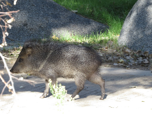
Loretta will be flying East soon to spend some time with her daughters and their families before Christmas.  I'll just be 'hanging out' with the 'locals' and digging the sunny Arizona skies.

Javelina - One of the 'Locals"
(Our First Sighting)


Sunday, November 22, 2015

Fun with Raven and Chickadee

Post by Henry and Loretta

On our journey so far this year, we rarely have a plan.  We've made very few reservations and I tell everyone that mostly we just have a 'general idea' of what lies ahead for us and it's worked out great.

After leaving Moab, our 'general idea' for heading south for the winter, gave us the chance to meet up with some friends in southeastern Utah.  This is an area I didn't do much research on and had originally thought we'd just pass through.  We spent five (5) nights at the Sand Island Campground on the San Juan River.  This was another scenic BLM (Bureau of Land Management) campground with no hookups outside the small town of Bluff, Utah.

We had a day or so before our friends arrived, so we drove out to see some nearby sights.

We stopped at Goosenecks State Park, which is little more than a scenic overlook, but what a view! Here the San Juan River forms tight switchbacks far below that is an amazing sight!

One of the Goosenecks

We passed through the town of Mexican Hat and saw the Mexican hat rock formation for which the town is named.

Mexican Hat Rock

We drove through Monument Valley - that was quite beautiful and looked a bit familiar only because it's been the filming location of countless western movies.

Monument Valley on a Cloudy Day

Our next three (3) days, we spent with Eric and Laurel, whom we met a couple of years ago in Florida.  They've been fulltime RVing for several years and their website ravenandchickadee.com has been a great source of both information and inspiration.  Check them out HERE

Eric and Laurel
of
Ravenandchickadee.com

As I mentioned, I didn't do much research on the area, but Eric and Laurel had been there before, and had hikes they wanted to do out to some ancient ruins and Petroglyph sites.

Now, these hikes weren't like a lot of hikes we do, with a signed parking area at the trailhead and nicely maintained trails.

Laurel Leading the Way

Oh, no!  These hikes came from information on the internet that just give you a 'general idea' of how to find these ancient sites.  Apparently, the Southwest US has countless places like this that take some research and effort to find.

Our first day turned into quite an experience!  We were headed to the Procession Panel Petroglyphs, and unknowingly, had parked about a quarter mile before the true trail head. We started by hiking through some oozing mud that turned our shoes into big gobs of goo.

Introduction to Canyon Hiking

Then we followed some rock cairns that should have lead us to the panel, but instead, we ended up on the opposite side of a huge wash from where we needed to be.  (A wash is a dry bed of an intermittent stream at the bottom of a canyon, typically dry, but subject to rapid flow during flash flooding).  Spotting another couple in the far distance, headed up the other side of the wash helped us realize we were on the wrong path, or we might not have ever found it.  Of course, now we had to hike back down into the canyon and then up the other side.

Going Back Down the Canyon

We eventually ran into the other couple on their way out and they gave us a 'general idea' of how to get back out to the correct parking area.

Anyway, we DID find the Procession Panel Petroglyphs and it was very cool!  To me, these were as good as the petroglyphs we saw earlier in the year at the Petroglyph National Monument in New Mexico, but here, they were pretty much in the middle of nowhere for anyone to find with some effort.  Or a LOT of effort.

Proof!  We Made it to Procession Panel Petroglyphs

Procession Panel Petroglyphs

I'd like to say our hike out went smoother, but it didn't.  We thought we'd follow some other rock cairns and they would lead us up the road a bit from where we parked.  Nope!  The cairns ran out at a field of sticker bushes that involved painful hiking to get through.  We followed this up with a steep descent into an overgrown wash (also known as sliding on your butt), that we had to navigate and then up (climbing, crawling, and digging) the steep other side.

About to do the Slide

The ride home was filled with jokes about 'never going to hike with each other again', but it was all in fun.

Mostly.

The next day, they took it a lot easier on us.

First, we hiked out to some ruins that were in amazingly good shape.  The ruins were reminiscent of what we saw at Mesa Verde, but on a much smaller scale.

Ancient Rock Structures

This site also included pictograms, some of which were merely hand prints.  To think of WHOSE hands they were, how long ago they were made. and now here we were, intently studying them, is just unreal.  There were small shards of pottery scattered about and even partial corn cobs that could be hundreds of years old!

Pictographs of Indian Hand Prints

Amazing!  Mostly Intact Corn Cobs and Grinding Stone

We followed this up with a much shorter hike to the Wolfman Petroglyph Panel.  These may have been the best petroglyphs we've ever seen.  We all commented they must have been made by THE artist of the people living here at the time.

Wolfman Petroglyph Panel


Wolfman Petroglyph Panel

We topped off the day with a scenic drive through the Valley of the Gods, which turned out to be even more impressive than Monument Valley, in our opinion.

Valley of the Gods

Valley of the Gods

Day three (3) was to be a hike out to ruins that Eric and Laurel had done a few years earlier, called House on Fire.  If you photograph this site at just the right time of day, the sun shining on the rocks make the ruins look like they are on fire in the picture.

Today's hike was Laurel, Loretta and I, as Eric stayed behind to catch up on some work.

We made the hour drive armed with more 'general idea' directions, and arrived at the trail head.  Or so we thought.

Laurel had told us it would be a fairly easy three (3) mile round trip hike out to the House on Fire location.  All we had to do is 'follow the wash'.

Long story short:
We followed the wrong wash.

This time, we parked about a quarter of a mile past where we should have.  The hike turned into a six (6) mile round trip hike, which included scaling a steep incline at the halfway point to some ruins, where someone declared, "This isn't House on Fire!".

NOT House on Fire

Awesome.

I can't say we were too disappointed, because we did come across several different ruin sites along the hike.  And again, to me, these were about as cool as Mesa Verde because we had them all to ourselves.

Another Set of Ruins

We did spend the rest of the day joking about 'never wanting to hike together again'.

All in fun.

Mostly.

That pretty much sums up our three adventurous days with Raven and Chickadee.

Sometimes our 'general idea' for traveling is influenced by the weather forecast, and the current forecast called for us to head further south to avoid possible snowy conditions.

In all seriousness, we would have liked to spend more time with Eric and Laurel, because we truly had a lot of fun. Our winter destinations are on opposite sides of the country, but we are planning on catching up with them again next summer in Washington, where they know ALL the good places to visit and hike.....

Mostly.

Thursday, November 5, 2015

Red Rock Country

Post by Henry and Loretta

On our continuing journey south for the winter, we stopped in Moab, Utah for about a week. We stayed at a BLM (Bureau of Land Management) campground called Ken's Lake, where we had views of the lake, lots of red rocks and the snow covered La Sal Mountains.

Ken's Lake

Snow Capped La Sal Mountains
at
Ken's Lake Campground


Faux Falls and Red Rocks
at
Ken's Lake

On the ride down, we were passing through rolling hills and somewhat mountainous terrain until we crested one mountain and BAM!!!  All of a sudden we were in Red Rock Country!  Canyons and mesas and all sorts of interesting rock formations.

Devil's Canyon

The Moab area is the pinnacle of red rocks with Canyonlands and Arches National Parks just outside of town. We were able to visit both of these parks.  After three (3) months of being in and around the Rocky Mountains, this was a totally different landscape.

Canyonlands National Park
Utah


Arches National Park
Utah

We spent a day at the Island in the Sky district of Canyonlands.  The views off into the canyons are just mind boggling to think of the forces of nature that took billions of years to form them.  Our photos just barely do the scenery justice, but they're far better than words.

Island in the Sky
Canyonlands National Park
(The ribbon is a road)

Island in the Sky
Canyonlands National Park

An Arch at Canyonlands

And the same with Arches.  It's truly amazing to see so many arches and stone towers in a relatively small area and to contemplate how they were formed over the course of time.

Rock Formation
Arches National Park

Balancing Rock
Arches National Park

Double Arch
Arches National Park

Unfortunately, due to the excessive rain earlier in the week, we were not allowed to hike out to the most famous of the arches, Delicate Arch. Four days of rain closed the road leading out to the trailhead due to flooding.

Flooding and a Rainbow after a Rainstorm
Arches National Park

There's not a lot of trees in either of these parks, but the two we noticed the most were Pinyon pines and Junipers.  Some of the most picturesque of these were the dead trees with their twisted branches and trunks.

Dramatic Scene

Amidst all this red rock country is a totally contrasting feature.  Southeast of Moab, in the distance, sits the La Sal Mountains overlooking the canyons and arches.  In summer you can be in the blazing heat of red rocks and within 20 miles, be high above with refreshing temps, tall evergreen trees, and cool mountain streams.  While we were in the area those four days of precipitation transformed the La Sal mountains into beautiful snow capped peaks!

Snow Capped La Sal Mountains
from
Ken's Lake Campground, Moab, Utah

I don't know how any times I can state "this is one of the most scenic places we've stayed".

But it was.

Again.


Wednesday, October 14, 2015

Southwest Bound

Post by Henry

Before we left Montana a few weeks ago, we had several days in a row of wet and chilly weather with snow in the nearby mountains.

First Snow of the Season
September 16, 2015
West Yellowstone, Montana

We're now slowly making our way southwest and so far, we have hardly seen a cloud in the sky, with temperatures up into the mid 80's.

Our first stop was barely 100 miles south at Juniper Campground on the Ririe Reservoir outside of Idaho Falls, Idaho.  This was a nice, quiet, county run campground with full hookups.  Besides being on the reservoir, the campground is located in the middle of miles of farmland and is full of fragrant juniper trees.

Our Campsite at Juniper Campground
Ririe, Idaho
Preparing for Winter

A short walk behind our campsite was a great view overlooking the green waters of the reservoir and the hill behind it full of windmills.  This was also a great spot to soak in some beautiful sunsets that occurred during our stay.

Sunset Overlooking
Ririe Reservoir

A Closer View of Sunset
Windmills and Irrigation Equipment

After eleven (11) nights at Juniper Campground, we moved further south to the Great Salt Lake area. We spent a week at a local campground that provided good access to explore the nearby area.

Brigham City, Utah
Proud of Their Bird Refuge

We made a trip out to the Bear River Bird Migratory Refuge.  The mosquitos and insects were rather intense, so this was mostly a drive around the refuge with windows UP.

Bear River Migratory Bird Refuge

Western Grebe
Yes, those are Mosquitos!

Snowy Egret

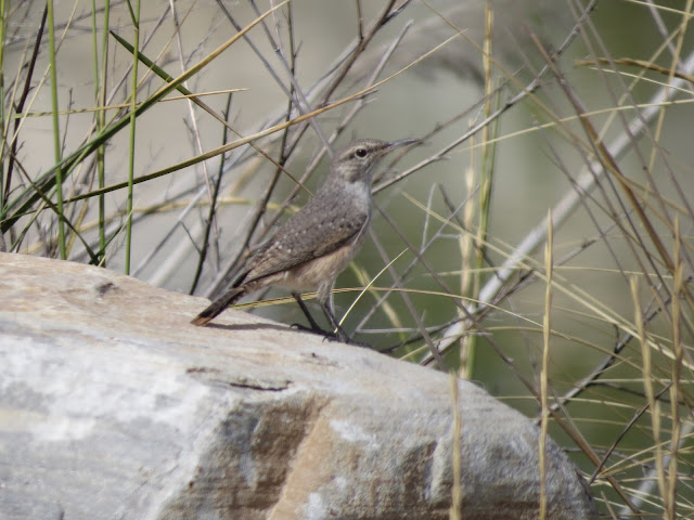
Rock Wren

We did some exploring in the Wasatch Mountains, where the aspens were in their full golden autumn glory.

Aspens in Fall

A Peek of Color

Next, we moved to Antelope Island State Park located right in the Great Salt Lake.  Loretta had visited here several times in the past couple of years, as her daughter's husband and family were recently stationed at nearby Hill Air Force Base.  She had always talked about spending some time here in the motorhome, and now we're doing it!  This park is quite spectacular with an amazing amount of wildlife, such as free roaming bison and pronghorns, not to mention the millions of birds that migrate through.

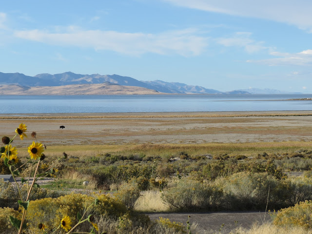
Antelope Island Buffalo Herd
(The Little Dark Dots)

A Closer View

The campground doesn't have any hookups, but this very well could have been the most scenic campsite on our journey so far with 360 degree views.

Camping on Antelope Island

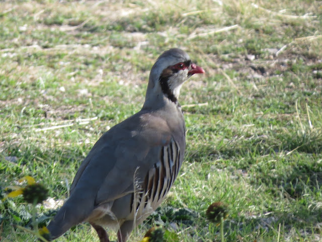
In one direction was the Great Salt Lake. Another direction was the Wasatch Mountains, looming in the distance.  Behind us were buffalo roaming a nearby hillside.  Close up, we had Jack Rabbits and a Quail-like bird called Chukar passing through our campsite.

Great Salt Lake, Bison, and Mountains

Chukar

Jack Rabbit

Over the next few weeks, we'll continue migrating towards southern Arizona for the winter.  In between we hope to visit Arches and Canyonlands National Parks, Monument Valley, Goosenecks State Park, the Grand Canyon, as well as anything else that catches our eye.


Bonus Pic!
Hippie Horse
PEACE!