Monday, June 29, 2015

New Mexico to Colorado

We enjoyed our time in New Mexico, where we finished out our month long visit at two (2) more State Parks and a City Park.

Elephant Butte Lake State Park features the largest lake in New Mexico

Elephant Butte Lake State Park
South Monticello Campground
Elephant Butte Lake

We spent the week leading up to Memorial Day here in South Monticello Campground, which didn’t even fill up over the holiday weekend.  Every campsite was very spacious and had a covered picnic table.  The weather was hot, dry, and windy as every other place we’d  stayed so far in New Mexico.

Coronado Campground is run by the city of Bernalillo, which is just outside of Albuquerque. This was a quaint little campground, previously owned by the state, and each picnic table was enclosed in it’s own painted adobe hut type shelter. 

Coronado Campground Picnic Shelter

The best part was our campsite overlooked the Rio Grande River and Sandia Mountain.
  
Our View from Coronado Campground at Sunset
Sandia Mountains and Rio Grande
Photo by Henry

While here, we did some stocking up on groceries and other supplies at our favorite places like Costco, Trader Joe’s, and REI.  We had been researching carbon fiber trekking poles and purchased them at Costco, since much of our hiking is rocky and mountainous, and Costco had the best price by far.  And we have found we like using them!

We spent part of a day checking out Petroglyph National Monument.  Another day we visited Old Town Albuquerque, which we found to be kind of touristy.  

We also rode the Rail Runner train up to Santa Fe and wandered the streets there for a whole day. 

Rail Runner to Santa Fe
Colorful Santa Fe

The most fascinating sight in Santa Fe is the Loretto Chapel.

The Famous Loretto Chapel

The story of the chapel, particularly of the spiral staircase is one of fascination and mystery.  Read more about it here by clicking on this link:  Loretto Chapel

The Mysterious Loretto Chapel Spiral Staircase

One observation we made while staying in the Albuquerque area was the people here are over-the-top friendly.  Everywhere we went and every person we met was so polite and almost comically nice.

Navajo Lake State Park is the northernmost and second largest lake in New Mexico

Navajo Lake State Park, New Mexico

The campsites here were a lot less spacious than the other New Mexico State Parks we’d stayed at.  Our site had just enough room to squeeze the Rambler in amongst some Juniper and Pinon Pine trees that afforded us some decent privacy.  The deep pine scent coming from these trees was oh, so heavenly, and would send our senses reeling every time we stepped outside.  The campground sits high above the lake and our site overlooked the large marina below, which was quite a busy and noisy place. 

Our View at Navajo Lake State Park

The San Juan River is the water source for Navajo Lake and the stretch of river below the dam is famous for world class fly fishing.  Well, we aren’t fishing type folks, but this same stretch of river was also a great place for us to get our kayaks wet for the first time since we left Florida!

Paddling the San Juan River

And THEN, we crossed over to Colorado…..

COLORADO!

Like I said, we enjoyed our time in New Mexico, but I swear, just crossing the Colorado state line, you get a different vibe.  Of course, the snow capped San Juan Mountains on the horizon probably had a lot to do with that vibe.  

Snow-capped Colorado Mountains

Almost immediately, though, it’s majestic mountains, towering evergreen trees, tumbling mountain streams, and rugged looking western towns welcome you to Colorado.

 
Idyllic Old Barn and Snow-Topped Mountains

Now, I’ve been to Colorado quite a few times on camping and backpacking trips over the years, but other than the Denver airport, Loretta has never been.  So early in our current journey, we decided to spend two (2) months of the summer in Colorado.  We’ve spent the first ten (10) days in the Durango area and there may not be a better place to start our time in this state. 

The Historic District is really cool, with it’s old western style buildings and streets lined with shops and restaurants.  This town has six (6) brew pubs and at least ten (10) coffee shops – my two favorites.  

Animas Brew Pub
Durango, CO

There’s the Animas River Trail, which is a paved pedestrian and bike trail that winds for seven (7) miles alongside the river and through town with numerous small parks and green space along the way.  We biked the entire trail - even the hills!

Biking the Animas River Trail

The most famous attraction in Durango is the Durango and Silverton Steam Engine train that has been in continuous service since 1882.  I rode this train several years ago with my backpacking buddies.  The train dropped us off in the Weminuche Wilderness and we spent five (5) days backpacking and then caught the train back to Durango.  (Flashback)

Durango & Silverton Steam Train

One day Loretta and I ventured out to Mesa Verde National Park on an unusually cool and rainy day.  To see these structures built several thousand years ago is mind boggling.
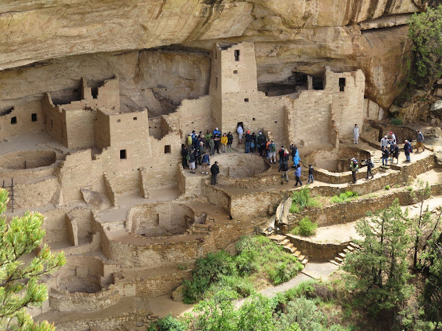
Mesa Verde Ancient Structures
The Cliff Palace
Square Tower House

We made a trip to Silverton, which sits at over 9,000 feet in elevation.  We had to travel over two (2) passes where there was still a good bit of snow on the ground. 

Snow in June at Coal Bank Pass
Elevation 10,640 feet

Near one of the passes we came upon several Bighorn Sheep licking the road!  

Bighorn Sheep

They were very intent on getting the salt or minerals off the pavement and did not seem to mind the vehicles that had to creep past them.

We're Busy - Go Around!

Silverton is a very old, rustic town that mostly survives on the three (3) train loads of tourists that are deposited here for the afternoon every day by the steam engine train.  There will be a future post on Silverton.

Of course, we also got in a couple of days of hiking.  One day we hiked a few miles of the Colorado Trail, which starts barely a few miles outside of town.  Another day we hiked a stretch of the Vallecito Creek Trail, which follows and rises high above this beautiful mountain stream.

View along Vallecito Creek Trail

I’ve been telling Loretta for years about Colorado and I think she’d agree.

This place is great!

And we get to spend at least two months here!


Friday, June 19, 2015

WOW! (We’re Out West!)

Post by Henry

Before we started this journey, folks would ask "So, where are you going?"  My usual response would be "West."
We recently entered New Mexico, which meant crossing into the Mountain Time Zone, so I officially proclaim that we are WEST!  WHOO HOO!!
We spent our first five (5) nights just outside Carlsbad at Brantley Lake State Park.

Brantley Lake State Park

Here we purchased a New Mexico State Park annual pass for $225, which entitles us to drastically reduced camping fees.  Our five (5) nights at Brantley Lake in a site with full hookups cost just $8 per night.  Water and electric only sites are $4 per night.

Brantley Lake is the southern most lake in New Mexico and was quite a departure from Davis Mountains as it’s quite flat.  And windy.  Ridiculously windy.  I mean rocking the motorhome windy!  It’s also full of rabbits.  Big Jack Rabbits and smaller desert rabbits.  Lots of them.

Bunny in Wildflowers

We got to see a couple of new birds here, the Scaled Quail and the Bullock’s Oriole.

Bullock's Oriole

After NEVER seeing any Montezuma Quail rumored to be in Davis mountains, we saw quite a few of the Scaled Quail scurrying across the roads and countryside here in New Mexico.  Speaking of scurrying across the roads we saw a lot more Roadrunners here than we’d seen in Texas, too.  Another new bird (to us) we saw here in the evenings was the Lesser Nighthawk.

While here, we checked out Carlsbad Caverns National Park, where we were able to use our America the Beautiful Pass to cover the entrance fee.  

Carlsbad Caverns

We had the option of taking the elevator down into the cavern or walk, so we walked.  The pathway goes down, down, down.  750 feet down!

Entrance to Carlsbad Caverns


Going Down, Down, Down!

It doesn’t take long before you are below the point where sunlight reaches and you start looking for the red man with horns!  The path is lit with strategically placed lighting to accent various formations plus just enough to see where you are going.  Once at the bottom, you arrive at the ‘Big Room’.  There is a path around the perimeter of this gigantic room past stalactites, stalagmites, and all sorts of formations in various shapes and sizes.

Gigantic Formations
The Bottomless Pit
Out of the Dark

All together, we spent about three (3) hours underground.  We had the option of taking the elevator or walking back up to the surface.  This time, we chose the elevator.

Just thirty (30) miles further up the road was Guadalupe Mountains National Park

Guadalupe Mountains National Park

It was kind of late in the day, but we probably weren’t going to be any closer to this park, so we headed that way.  Once there, we did little more than stop by the Visitor Center to get my National Park Passport book stamped.  It’s not a very big park, but it’s described as a ‘hiker’s park’.  Since hiking is about my favorite thing to do, I’ll need to return here someday – probably when it’s a little cooler.

Another day, we drove up to the small town of Artesia, mainly to grab a bite at their number one rated restaurant - according to Trip Advisor - only to find out it was closed because it was Mother’s Day.  Really?!  Isn’t Mother’s Day the busiest day of the year for restaurants?

We ended up going to Roswell, which is much bigger than Artesia and where almost everything revolves around UFO’s.  So many businesses here had green alien statues out front or signs that read ‘Aliens Welcome Here’.  It was mostly kind of amusing. 

Aliens in Roswell

After Brantley Lake, we headed further west to Oliver Lee Memorial State Park.

Oliver Lee Memorial State Park

This park is just outside of Alamogordo nestled next to the Sacramento Mountains rising up from the surrounding flat high desert, providing us our most spectacular campsite view ever!

Our Campsite at Oliver Lee
The View Across the Desert

We spent quite a bit of time here just staring at these mountains muttering about how beautiful they were.

View From Our Campsite

In the other direction, we could see the White Sands National Monument in the distance. It was an obvious strip of white amid the otherwise brown surrounding landscape.  It was even more obvious on the very windy days when we could see clouds of sand blowing.  Oh, and apparently it’s always windy here in New Mexico – at least so far in our time spent here.

Here at Oliver Lee, the Gamble Quail was the most prevalent.
  
Gamble Quail

We observed them running through the desert brush and heard them calling daily.  One day we spotted two males fighting fiercely.  We watched for several minutes as they continued to attack each other, seemingly with no intention to cease the battle.

We visited the White Sands National Monument one day.

White Sands National Monument

Somehow, they keep a road cleared that you can drive out to experience being surrounded by the ever changing sand dunes. It is one BIG sandbox!  We even climbed to the top of one of the dunes. 
 

Henry Walking to the Top of a Sand Dune

We managed to visit the park on a ‘less windy’ day and also a day after it had rained the evening before, so the sand was somewhat packed down.  I imagine it might be a painful experience on a day with the sand being kicked up by the wind.

White Sand and Blue Sky

One day we visited the town of Cloudcroft, which is barely fifteen (15) miles outside of Alamogordo, but sits on top of the Sacramento Mountains at 8,600 feet elevation.  It’s at least 20 degrees cooler there, so I imagine it’s a great place to be when the heat of summer kicks in.

Cloudcroft, NM
Steller Jay

On our last day at Oliver Lee, we hiked the Dog Canyon Trail here at the park.  

Henry on the Dog Canyon Trail

We’d been eyeing this trail from our campsite as it rises steeply from behind the park office.  And yes, it DOES rise steeply – especially the first half mile!  

Dog Canyon Trail - whew!

Again, somehow we picked a less windy day with hardly a cloud in the sky and the views when we stopped to catch our breath were outstanding.  

View from Dog Canyon Trail

We hiked three (3) miles gaining 1,500 feet in elevation to the remains of a stone cabin sitting next to a creek at the top of Dog Canyon.

Remnants of a Stone Cabin

At the creek, we came upon some bright yellow Columbines, which were the first we’d seen on our trip.

Yellow Columbines

Also, there were hummingbirds buzzing around so quickly we never could get a good look at one, but their buzzing sound was unlike other hummingbirds we have heard.  We later found out they were Broadtail Hummingbirds.  The hike back down Dog Canyon may have been even more beautiful, as the views were ever present in front of us as we made our way along the rocky trail.

We were pretty wore out and a bit sunburned when we got back to the Rambler, but this was the perfect way to end our trip to Oliver Lee State Park, as we spent one last evening admiring the mountains from our campsite.

Not a Bad View!

Our first New Mexico Sunset